|
||||||||||||||||||||||||||||||||||||||||||
|
||||||||||||||||||||||||||||||||||||||||||

| Ladybug6
Back
to Teledyne FLIR
|
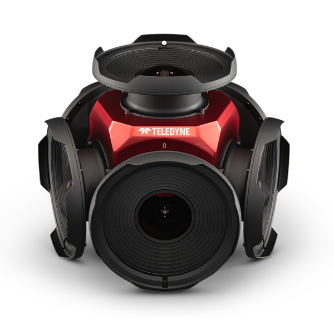 |
| The Ladybug6 by Teledyne FLIR is a 360-degree high
resolution camera designed to capture spherical images from moving
platforms in all-weather conditions. The Ladybug6 provides ultra
high resolution imaging at 12,288 x 6,144. At its full resolution
it provides users with a frame rate of 15 FPS. The Ladybug6 is an
industrial grade camera that combines global shutter CMOS sensors
and high-end optics to deliver images with pixel values that are
spatially accurate within +/- 2 mm at a 10-meter distance. The Ladybug6
is designed for applications like panoramic street images, road
surveying, asset inspection, feature extraction for HD map generation
and much more.
The Ladybug6 builds on Teledyne FLIR's Ladybug range of cameras with increased image resolution, enhanced on-board processing, and robust IP67-rated connectors. Support for additional Global Navigation Satellite Systems and advanced APIs, combined with hardware inputs, enable precise camera settings and trigger control. The Ladybug6 captures, compresses, and transmits 8-bit or 12-bit pixel data with on-board image processing for optimized workflows. The Ladybug6 is available in either a black or red coloured housing. |
| Key Features: |
| High Resolution Imaging: |
| Capable of capturing 12,288 x 6,144 (72 MP) |
| Superior Accuracy: |
| Provides an accuracy level of +/- 2 mm at a 10-meter distance |
Enhanced On-Board Processing: |
| Improved on-board processing capabilities allow for faster and more efficient image capture and processing. |
| Support for Additional Global Navigation Satellite Systems (GNSS): |
| Integrates with more GNSS, enhancing location accuracy and geospatial data integration. |
| Applications |
| Mapping and Surveying: |
| High-precision mapping and surveying for construction, urban planning, and infrastructure management. |
| Heritage and Preservation: |
| Detailed documentation and virtual tours of historical sites and artifacts for preservation and educational purposes. |
| Security and Surveillance: |
| Comprehensive 360° monitoring for security applications in public spaces, airports, and other critical areas. |
| Industrial Inspection: |
| Inspection of large structures, such as bridges and towers, as well as confined spaces where traditional cameras cannot reach. |
| Training and Simulation: |
| Realistic training simulations for various fields, including military, aviation, and emergency response. |
|
|
|
Specifications
|
LD6-U3-122S7C-R
|
LD6-U3-122S7C-B
|
| Resolution |
12,288 x 6,144 (72 MP)
|
|
| Frame Rate |
15 FPS JPEG at 72 MP resolution / 29.9 FPS JPEG
at 36 MP resolution
|
|
| Readout Method |
Global shutter
|
|
| ADC |
12-bit
|
|
| Chroma |
Colour
|
|
| Operating temperature |
-30° to 50°C
|
|
| Mass |
5.2 kg
|
|
| Sensor Type |
CMOS, Sony IMX264
|
|
| Interface |
USB 3.1 Gen 1
|
|
| Dimensions [W x H x L] |
198 mm (Height) x 269 mm (Diameter)
|
|
| Colour |
Anodized red
|
Anodized black
|
| Datasheet | ||
|
If you like this page, please recommend and share it. |
||
| More | ||